Severe weather activity settles closer to average this week, but several regions remain worth watching as a cold front moves from the Great Lakes toward the East Coast and additional storm opportunities develop across the Plains.
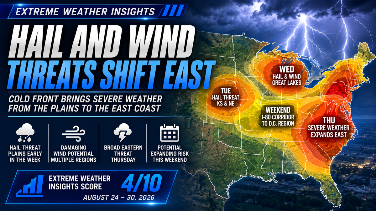
For August 24–30, 2026, Dr. Gensini gives this week's forecast an Extreme Weather Insights Score of 4/10—representing average to slightly below-average severe weather activity.
The most notable opportunities include hail across the Great Plains early in the week, hail and damaging winds around the Great Lakes on Wednesday, a broad severe-weather corridor across the eastern U.S. Thursday, and a potentially expanding Plains-to-East threat heading into the weekend.
Last Week: The Forecasted Hail and Wind Corridors Developed
Last week's 5/10 forecast produced two distinct areas of severe weather.
Across the Central Great Plains, storms were primarily dominated by hail. Farther east and south, the Southeast experienced widespread damaging winds, including activity extending into Mississippi, Alabama, and Louisiana.
Overall, the forecast captured the two primary areas of activity well, although the damaging wind corridor ultimately extended farther south and west than originally anticipated.
Hail Remains Below Average
The seasonal hail trend continues to run below normal.
Approximately 4,600–4,650 hail reports have been recorded through August 23. For comparison, 2019 had recorded 4,741 reports by the same point in the year before ultimately finishing somewhat below average.
September represents the final portion of the peak hail season, leaving some opportunity for the seasonal numbers to increase. For now, however, 2026 continues to track toward a below-average hail year.
Damaging Wind Is Approaching Historic Territory
Wind continues to tell a very different story.
Approximately 18,500 damaging wind reports have now been recorded through August 23, putting 2026 among the most active damaging-wind years in recent history.
The only year currently running clearly ahead is 2011, which had approximately 22,000 reports at the same point and stands as one of the most prolific severe-weather seasons in modern history.
While reaching 2011's pace may be difficult, a season finishing somewhere around 20,000–22,000 wind reports would still make 2026 an exceptionally active year compared with much of the past 15–20 years.
For roofing, restoration, and exterior contractors, that makes wind an especially important part of the storm opportunity picture this year—not just hail.
Monday: Dakotas, Nebraska and the Carolinas
The week begins relatively quietly before a stronger frontal passage starts generating thunderstorms.
The primary Plains risk extends from the eastern Dakotas into the Nebraska Panhandle, where strong to severe storms are possible.
A second, isolated corridor exists across the Carolinas. An isolated tornado cannot be ruled out, but damaging wind is expected to be the primary concern.
Tuesday: Hail Potential Across the Great Plains
Tuesday shifts the focus toward western Kansas and southern Nebraska.
While this area contains fewer major population centers, the atmospheric setup should be favorable for hail-producing thunderstorms.
For contractors operating across the central Plains, this will be the primary area to monitor Tuesday.
Wednesday: Great Lakes and High Plains Come Into Focus
Wednesday introduces two distinct severe-weather opportunities.
A weak cold front begins moving through the Great Lakes, bringing strong to severe thunderstorms into a corridor that includes Chicago, St. Louis and potentially Detroit.
Storms along the front could produce damaging winds along with hail ranging from approximately quarter size to potentially ping-pong-ball size.
Farther west, terrain-driven storms are expected across the High Plains, particularly east of Denver and north toward Cheyenne and the Laramie Range. Strong to severe storms with hail will be possible across portions of Colorado and Wyoming.
Thursday: Severe Weather Expands Across the East
Thursday could bring the week's broadest geographic threat.
As the cold front strengthens and moves east, the primary severe-weather corridor could extend from Vermont south through the Mid-Atlantic and into the Piedmont of Georgia.
Strong to severe thunderstorms will be possible along this corridor as the front advances.
Meanwhile, another round of severe storms is possible farther west, with the High Plains threat shifting north toward the Black Hills region of South Dakota.
For roofing and restoration companies across the eastern U.S., Thursday is one of the most important days to monitor this week.
Friday: Dakotas Could See Another Round
Forecast confidence begins to decrease Friday.
There should be enough moisture and wind shear to support severe weather across portions of the northern Plains, but exactly where the strongest ingredients come together remains uncertain.
The current outlook favors the Dakotas, where both damaging winds and hail will be possible.
Weekend: A Broader Corridor Could Develop
The weekend forecast remains less certain, but the potential geographic footprint begins to expand.
On Saturday, the primary area to monitor follows the Interstate 80 corridor from Nebraska through Iowa, where damaging winds and large hail could develop.
By Sunday, that corridor could extend significantly farther east.
Current guidance suggests a broad area generally near and south of I-80 stretching from around Omaha toward the Washington, D.C. region could support thunderstorms.
That represents a substantial amount of populated territory, but the exact placement and intensity of the severe-weather threat remain uncertain this far out.
Late-summer severe weather can be particularly difficult to forecast beyond five or six days, so the weekend outlook will need to be refined as the week progresses.
What Roofing Contractors Should Watch This Week
This week's 4/10 forecast isn't defined by a single major outbreak. Instead, storm opportunities move through several regions as the week progresses:
Monday: Eastern Dakotas, Nebraska Panhandle and Carolinas
Tuesday: Western Kansas and southern Nebraska, with hail potential
Wednesday: Chicago, St. Louis and potentially Detroit; Colorado and Wyoming High Plains
Thursday: Broad eastern corridor from Vermont through the Mid-Atlantic into Georgia; Black Hills region
Friday: Dakotas, with hail and damaging wind possible
Saturday: I-80 corridor from Nebraska through Iowa
Sunday: Potentially broader corridor extending from around Omaha toward Washington, D.C.
The exact weekend positioning remains uncertain, making updated storm intelligence particularly important as the forecast evolves.
From Forecast to Action
For contractors, knowing that severe weather is possible across a broad region is only the beginning.
The opportunity becomes more actionable once storms actually occur.
PSAI Extreme Weather Intelligence helps contractors move from forecast awareness to market activation by tracking storm activity, visualizing hail and wind events, identifying potentially impacted neighborhoods, and building targeted audiences around the areas that matter.
Monitor the storm → Identify impacted areas → Prioritize opportunity → Build an audience → Activate targeted outreach
That becomes particularly valuable during a week like this one, when the threat moves between multiple markets and forecast confidence decreases farther into the week.
Instead of treating an entire state or region as a storm market, teams can use actual weather intelligence to narrow their focus after storms move through.
Bottom Line
The August 24–30 Extreme Weather Insights Score is 4/10, putting the upcoming week around average to slightly below average overall.
Hail opportunities develop across the Plains early in the week before a cold front brings hail and damaging winds through populated Great Lakes markets Wednesday and a much broader eastern corridor Thursday.
The weekend could bring another expanding severe-weather opportunity from Nebraska and Iowa east toward the Mid-Atlantic, although the exact placement remains uncertain.
And behind this week's forecast is a larger 2026 story contractors should continue watching: hail remains below average, while damaging wind activity has climbed to approximately 18,500 reports—putting this year near historic territory for wind.

Meet the Next Evolution of PSAI: From AI Assistance to AI-Powered Action
Hurricane Isaias: 110 MPH Winds Threaten Florida Panhandle as Landfall Nears

How Good Roof Co. Is Unifying Its Marketing, Website, and AI Strategy With Predictive Sales AI

Google Local Services Ads Update: Missed Calls Can Now Cost Contractors Money

How Lutgen Companies Is Using Better Data, Better Marketing and One Platform to Build for Growth
Subscribe to Predictive Sales AI, LLC's Blog

Comments