After a relatively quiet stretch, severe weather activity is expected to increase again during the week of July 20–26.
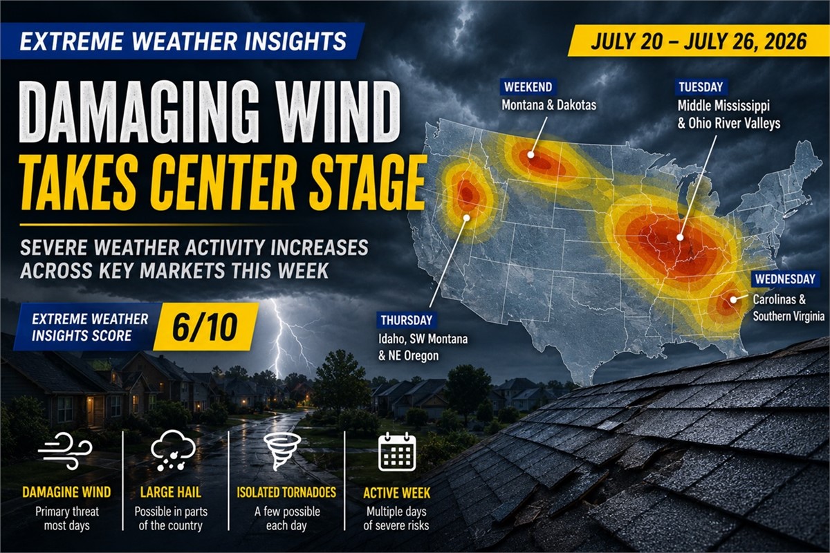
The latest Extreme Weather Insights forecast calls for a slightly above-average week, earning a score of 6/10. While large hail remains limited compared to previous seasons, damaging winds are expected to drive most of this week’s storm impacts.
The biggest event is currently forecast for Tuesday across the Middle Mississippi and Ohio River valleys, where storms could affect several highly populated markets.
Last Week: Limited Hail, but Wind Stayed Active
Last week carried an Extreme Weather Insights Score of 5/10 and remained fairly quiet overall.
Severe weather was scattered across Montana, the Dakotas, New England, the Mid-Atlantic, and the Carolinas. The most notable hail reports occurred across northern New York, while the broader story was once again damaging wind.
Last week produced 846 wind reports, which was well above average despite the limited overall storm coverage.
July has remained especially quiet from a hail perspective. Only about 50–60 large hail reports have been recorded this month, continuing a season that could finish near historically low levels unless activity increases later in the year.
For roofing and restoration companies, that trend reinforces the need to monitor wind-driven damage rather than relying exclusively on major hail events.
Monday: Iowa and Wisconsin Become the First Areas to Watch
The week begins with storms moving through northern Iowa and into northwest Illinois.
Initial activity should primarily bring heavy rain and localized damaging winds. However, additional storms may redevelop later in the day across central and eastern Iowa and southwest Wisconsin.
Those storms could produce:
- Very large hail
- Damaging winds
- Isolated tornadoes
The strongest Monday threat appears centered across southwest Wisconsin and portions of Iowa.
Tuesday Could Be the Biggest Storm Day of the Week
Tuesday is the day contractors and restoration teams should watch most closely.
As the system pushes east, a broad and populated area across the Middle Mississippi and Ohio River valleys could experience widespread severe weather.
Damaging wind is expected to be the primary threat, with the potential for several hundred reports from Tuesday’s activity alone.
Additional hazards may include:
- Isolated large hail
- A few tornadoes
- Organized thunderstorm clusters
- Widespread property damage
The combination of strong winds and exposure across populated markets makes Tuesday the most significant opportunity of the week.
Wednesday: The Threat Moves Into the Carolinas and Virginia
By Wednesday, the cold front continues moving toward the Southeast.
Southern Virginia and the Carolinas become the main focus, with damaging winds expected to remain the most likely severe weather hazard.
Although this setup may not produce widespread large hail, localized wind damage could still create meaningful inspection and restoration demand across the region.
Thursday Brings an Unusual Pacific Northwest Risk
A less common severe weather setup develops Thursday across portions of the Pacific Northwest and northern Rockies.
Areas to monitor include:
- Idaho
- Southwest Montana
- Northeast Oregon
Storms in this region may produce large hail and damaging winds.
These areas are less populated than the Midwest and Eastern storm corridors earlier in the week, but the setup remains notable because severe weather of this intensity is less common in the region.
Weekend Activity Shifts North
Heading into Friday and the weekend, the main storm corridor moves toward the northern United States.
Severe thunderstorms are expected along a cold front stretching through:
- Montana
- North Dakota
- South Dakota
- Far northwestern Minnesota
- Upper Midwest
- Great Lakes
Much of the strongest activity may remain across southern Canada, but storms forming along the southern edge of the front could still produce hail and damaging winds across U.S. markets.
What Roofing and Restoration Companies Should Watch
This week’s most important markets and timing include:
Monday
- Central and eastern Iowa
- Southwest Wisconsin
- Northwest Illinois
Tuesday
- Middle Mississippi Valley
- Ohio River Valley
- Populated Midwest markets
Wednesday
- Southern Virginia
- North Carolina
- South Carolina
Thursday
- Idaho
- Southwest Montana
- Northeast Oregon
Friday–Sunday
- Montana
- Dakotas
- Northwestern Minnesota
- Upper Midwest and Great Lakes
Bottom Line
This week is expected to be more active than last week, but damaging wind—not hail—will once again lead the severe weather story.
Tuesday currently presents the greatest potential for widespread impact, especially across populated portions of the Middle Mississippi and Ohio River valleys. Additional opportunities develop across the Carolinas, Pacific Northwest, northern Plains, and Upper Midwest as the week progresses.
With an Extreme Weather Insights Score of 6/10, roofing contractors and restoration teams should be prepared for a steady stream of wind-driven storm opportunities throughout the week.



Subscribe to Predictive Sales AI, LLC's Blog

Comments