After several weeks of average to below-average activity, severe weather season appears ready to make up ground in a big way.
According to this week's Extreme Weather Insights forecast, the second full week of June is shaping up to be one of the most active periods of the season so far. Large hail, damaging winds, and possible tornadoes are expected across multiple regions of the country, creating opportunities for roofing contractors, restoration companies, insurance professionals, and storm response teams.
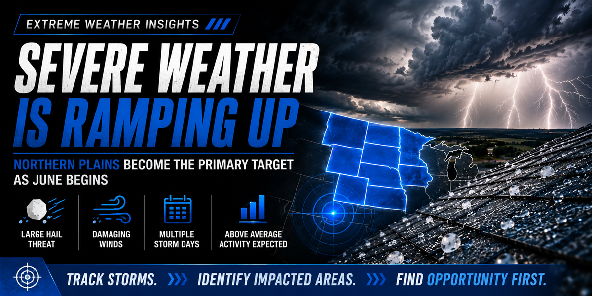
With an Extreme Weather Insights score of 8 out of 10, forecasters expect activity to be widespread and persistent throughout the week.
Northern Plains Continue to Lead the Way
Last week, the Northern Plains remained the focal point for severe weather activity.
More than 200 hail reports were recorded across the region, while the United States also experienced over 1,000 damaging wind reports. Large hail was concentrated primarily across the Dakotas, Nebraska, Montana, and surrounding areas, while wind-driven events stretched farther east through portions of the Mississippi Valley and Mid-Atlantic.
Some areas of southern Pennsylvania reported wind gusts exceeding 80 mph, creating potential property damage and inspection opportunities.
While overall hail activity has remained near average this season, forecasts suggest that trend could change quickly this week.
Tuesday and Wednesday Are the Days to Watch
The most significant severe weather threat is expected during the middle of the week.
Monday's activity will focus on northeast Colorado and portions of South Dakota, where large hail development is possible.
By Tuesday, the threat shifts into the eastern Dakotas and western Minnesota, where atmospheric conditions become increasingly favorable for severe thunderstorm development.
Wednesday currently appears to be the most impactful day of the week.
Forecasters are monitoring the Twin Cities region, Siouxland, western Minnesota, and eastern portions of the Dakotas for the potential of very large hail, damaging winds, and isolated tornadoes. The combination of strong instability and abundant moisture could create ideal conditions for significant severe weather.
For contractors operating in these markets, Wednesday may represent one of the most important storm-tracking days of the season so far.
Major Population Centers Enter the Risk Zone
By Thursday, a strong cold front pushes eastward into some of the country's largest metropolitan areas.
Cities at risk include:
Chicago
Indianapolis
St. Louis
Kansas City
Topeka
Oklahoma City region
While hail sizes may decrease compared to earlier in the week, damaging wind potential increases substantially. Large population centers combined with widespread storm coverage could create significant opportunities for inspections and storm-related services.
Severe Weather Shifts East Late Week
As the week progresses, storm activity spreads into the eastern United States.
Friday and Saturday bring the potential for damaging winds and scattered hail from the Southeast through the Mid-Atlantic and Northeast.
Forecast models currently show risk extending from Atlanta through Washington D.C., Philadelphia, New York City, and Boston.
Although hail sizes are expected to be smaller in many eastern markets, widespread wind damage remains a concern and could generate substantial storm response opportunities.
Plains Activity Returns for the Weekend
While the eastern U.S. remains active, the Plains are expected to reload.
Additional hail-producing storms are forecast to develop across portions of the Great Plains during the weekend, continuing a pattern that has persisted throughout much of the season.
Specific locations and hail sizes remain uncertain this far out, but the overall setup suggests that severe weather opportunities will remain elevated through at least the middle of June.
What This Means for Roofing and Restoration Companies
The biggest takeaway from this week's forecast is simple: severe weather is no longer confined to a handful of isolated regions.
Contractors should monitor multiple corridors this week, including:
Colorado and South Dakota (Monday)
Dakotas and Minnesota (Tuesday–Wednesday)
Midwest population centers (Thursday)
Mid-Atlantic and Northeast (Friday–Saturday)
Great Plains (Weekend)
With an 8/10 activity score and severe weather expected across much of the country, this week represents one of the broadest opportunities of the season for companies that rely on weather-driven demand.
After a slower start to June, storm season is accelerating—and many of the nation's largest markets are now entering the path of potential impact.
Tags
Subscribe to Predictive Sales AI, LLC's Blog


Comments